.jpg)
.jpg)
RD8100 Cable, Pipe and RF Marker Locator
- Powerful tool that helps operators pick out their target line from others nearby. With CD you can locate your utility quickly and eliminate wasted time
- RD8100 is the most advanced locator range
- Contains unique range of 5 custom manufactured, precision ground antennas
- Current Direction and iLOC combine with the versatile Tx Transmitter range to deliver highly responsive locates even in tough conditions.
- Integrated GPS and usage-logging options automatically generate data for reports
- In-house quality and safety audits to promote best working practices
- GPS equipped RD8100 locators automatically log key locate parameters every second
- Power Filters to pinpoint and discriminate between power cables
- Save up to 1,000 survey measurements, capturing utility depth, and send to a mobile device using Bluetooth
.JPG)
.JPG)
.JPG)
.JPG)
The RD8100 can passively detect the electromagnetic fields from live AC power or radio signals travelling along some conductive utilities. It can also be used in conjunction with a transmitter connected directly to accessible, metallic pipes, risers, or tracer wires. A current is sent through the pipe or tracer wire at a specific frequency and the resulting EM field can then be detected by the receiver. If access directly to the utility is not possible, we can send tone via induction, however this lessens the accuracy of the location. The ability to locate depends on a variety of factors including access to the utility, conductivity, grounding, interference from other fields, and many others. Depths provided should always be treated as estimates as their accuracy can be affected by multiple factors.
GPR (Ground Penetrating Radar)
Ground Penetrating Radar, GPR is a geophysical method that uses radar pulses to image the subsurface. This nondestructive method uses electromagnetic radiation in the microwave band (UHF/VHF frequencies) of the radio spectrum, and detects the reflected signals from subsurface structures. GPR can have applications in a variety of media, including rock, soil, ice, fresh water, pavements and structures.
- GPR uses high-frequency (usually polarized) radio waves, ususally in the range 10MHz to 2.6 GHz.
- GPR transmitter and antenna emits electromagnetic energy into the ground
- Data is collected in parallel transectss and then palced together in the appropriate locations for processing.
- Dual-frequency (400/800 MHz) GPR Cart w/large wheels, composite weather cover, Li-Ion battery and charger, Ram tablet mount and Android acquisition software
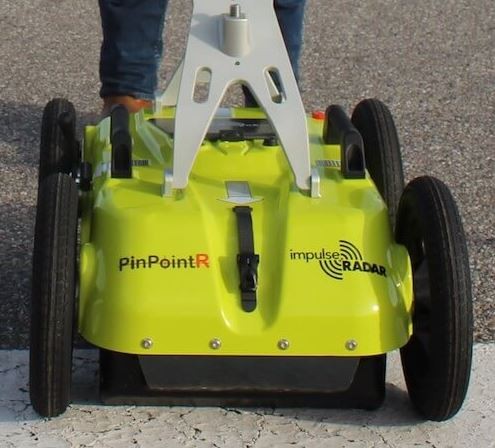
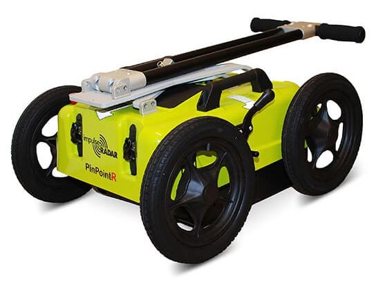
Key Features:
- ImpulseRadar RTS-based antenna technology.
- Internal data security.
- Dual-channel operation 400 MHZ (LF) & 800 MHz (HF)
- Integrated GPS, with external GPS support (NMEA 0183 protocol)
- No survey speed limitation.
Vermeer Excavation System

Whether you’re clearing debris or excavating underground infrastructure, you want to have the right tools for the job. When your worksite involves maneuvering around fragile pipes, collecting tough debris or simply cleaning up after a larger project, the machines you use should be powerful yet precise. Vaccum trucks are used to break up, collect, and haul away soil and other debris.
- The LP SDT series includes a Yanmar 49-hp (36.5-kW) Tier 4 Final diesel engine with 1,000 cfm (1,699 m3/hr) vacuum blower for both wet and dry applications. Manufactured on a durable, low-profile trailer.
- Hose length: 30 ft (9 m)
- Vacuum: 1000 cfm (28 cubic m/min).
- 800-gal (3028.3-L) heavy spoil tank option
- 2 tanks with a Water capacity of 400 gal (1514 L)
- 800-gal (3028.3-L) heavy spoil tank option

.jpg)
.jpg)
EQUIPMENT INDEX
.png)