.jpg)
Captain Tim R. Carlile, PLS President
Check out Tim's profile on Linkedin: www.linkedin.com/pub/tim-carlile/16/437/a49/
Professional Registrations
Professional Surveyor- Florida, Georgia, Alabama, Mississippi, Louisiana, Texas and US Virgin IslandsEducationLand Surveying and Site Development Courses, Community College of the Air Force & Valencia Community College
Other CertificationsHYPACK Certified HydrographerUSACE Construction Quality Management (CQM) OSHA 30 & 10-hour General Industry Training CPR and First Aid NAUI Advanced Scuba Diving certificationHazwoper 24-hour CourseTWIC Card USCG Captain's License – 100-ton MasterSeaBat Multibeam Echosounder CertificationFAA Remote Pilot
Other CertificationsHYPACK Certified HydrographerUSACE Construction Quality Management (CQM) OSHA 30 & 10-hour General Industry Training CPR and First Aid NAUI Advanced Scuba Diving certificationHazwoper 24-hour CourseTWIC Card USCG Captain's License – 100-ton MasterSeaBat Multibeam Echosounder CertificationFAA Remote Pilot
.jpg)
Tim Carlile is the President and founder of Land & Sea Surveying Concepts, Inc. He has over 44 years of experience in all aspects of the surveying profession. He oversees the day to day operations of the field crews and office staff. Mr. Carlile supervises all surveying activities and provides quality control for all Land & Sea Surveying projects. He also performs the quality control review of the field work and all survey drawings. Mr. Carlile has worked his way through the ranks from an entry-level rodman to founding Land & Sea Surveying in 1992. On a daily basis, he continues to be an integral part of all projects, from working in the field to performing office calculations and drafting. Mr. Carlile and Land & Sea Surveying Concepts have provided surveying services under continuing services contracts to the Sebastian Inlet Tax District since 2004, the Canaveral Port Authority for 5 years, and partnered with engineering firms under the 45th Space Wing’s Technical Engineering and Spacelift Services contract for 15 years.
Mr. Carlile is an expert in the following software programs: MicroStation · HYPACK · Terramodel 4.10 · HYSWEEP · PDS2000 · Chesapeake Technology SWM · MAGLOG NT · MAG PICK · CORPSCON · Trimble TDS Survey Link
His experience extends beyond the traditional surveying to using ROV, USBL and CTD equipment for environmental surveys and Single–beam, Multi-beam, Side Scan, Magnetometer, and Sub-bottom profiler for hydrographic surveys. He is also an experienced diver and has performed many dives for visual inspection of underwater conditions.
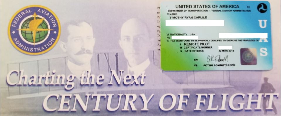
Tim Carlile's Remote Pilot License
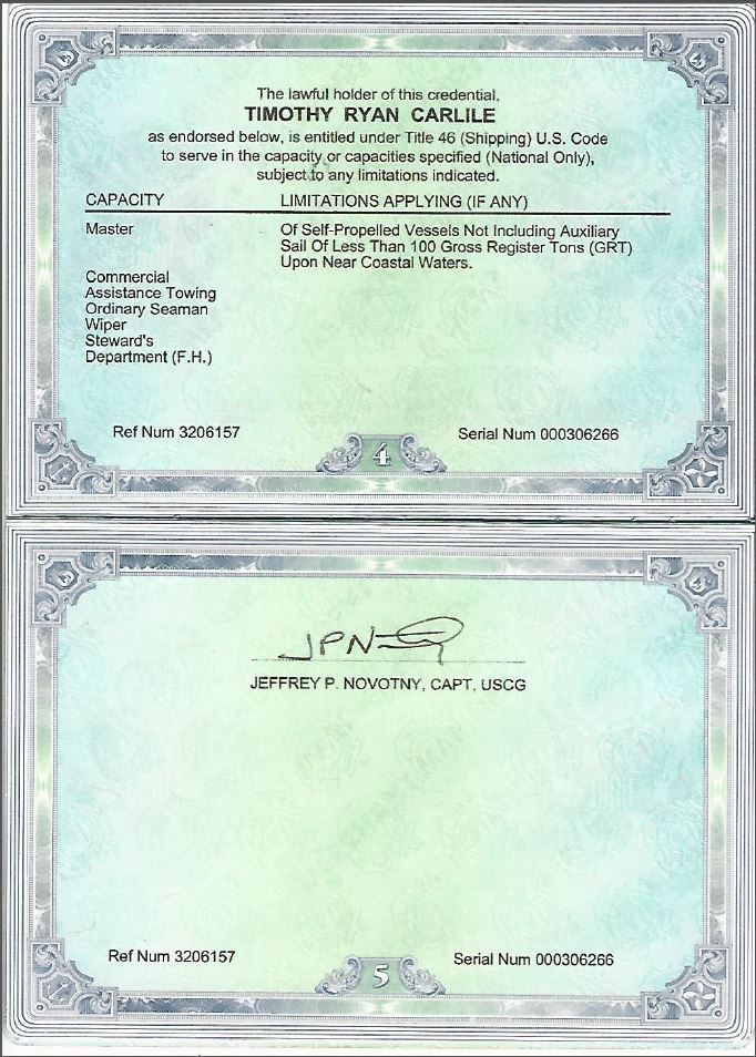
Tim Carlile's USCG Credential
Jose Montana Senior Party Chief
Surveying from Heaven †
Jose Montano had over 50 years of experience in the survey field and had grown with the surveying profession. With his in-depth knowledge of the mathematics and geometry of surveying, he was our resident expert on boundary surveying, construction layout and control surveys. Mr. Montano was directly responsible for the field management and training of the survey crew. He was responsible for ensuring that he and his crews maintain the highest possible accuracy. His many years of experience had provided him with the expertise necessary to be an extremely effective manager. Additionally, Mr. Montano worked closely with our CAD Manager to ensure the efficient and accurate delivery of field data to their department for calculations and drafting. Jose Montano passed in February 2021, and we remember him for his commitment and hard work over the years in the surveying profession, as well as his contributions to Land and Sea Surveying.
Suzanne Carlile Office Manager
EducationBachelor of Science in Business Administration/Finance, University of Central FloridaAssociate of Arts, Miami-Dade Community CollegeCertificationsOpen Water Scuba DiverSeaBat Multibeam Echosounder Certification CPR & First Aid
ExperienceSuzanne Carlile came to Land & Sea Surveying in 2004 with fourteen years of experience. Her previous experience in banking, government, and corporate accounting has provided a solid background for her role as Office Manager/ Accountant. As the Office Manager, Suzanne's responsibilities include all accounting functions, insurance policy administration, contract administration, researching and preparing proposals for all projects, scheduling of crews, and ensuring project deadlines are met.
Suzanne also works as a field survey technician and CAD operator. She is proficient with the Ashtech/Magellan GPS survey systems and in operating both singlebeam and multibeam hydrographic survey systems. She is likewise knowledgeable on the following software for data collection, post-processing and drafting:
Suzanne also works as a field survey technician and CAD operator. She is proficient with the Ashtech/Magellan GPS survey systems and in operating both singlebeam and multibeam hydrographic survey systems. She is likewise knowledgeable on the following software for data collection, post-processing and drafting:
- MicroStation V8i
- Terramodel 10.61
- HYPACK 2012
- PDS2000
.jpg)
Scott Sharpe Contract Employee - Marine Instrumentation Specialist and Hydrographic Survey Specialist
EducationElectronic Engineering Technology, DeVry Institute of TechnologyCertification HYPACK Certified Hydrographer
ExperienceMr. Sharpe has over 25 years of experience in ocean engineering with significant accomplishments in COTS system integration, ocean current measurment tecniques, bathymetric survey systems development, sub-bottom profilers, buoy mooring design, ocean bottom seismometer systems, marine seismic data acquisition, navigation and marine surveying. He has been working with Land & Sea Surveying for 15 years and is an expert on all hydrographic equipment and data collection software.
Scott's over all responsibilities include project management, data collection with single-beam, multi-beam, side scan sonar, magnetometer, and sub-bottom profile hydrographic systems, current meter preparation and data retrieval, tide gauges, USBL navigation, vibracore operations and Senior ROV pilot.
- Significant experience in field operations and oceanographic instrumentation preparation having participated in over 125 oceanographic cruises.
- Marine survey experience in bathymetric single beam and multi-beam surveying, sediment mapping surveys, sediment sampling surveys, magnetometer, side-scan surveys, reservoir life and volumetric studies.
- Project management, including multi-vessel geophysical, bathymetry, video, ROV, magnetic and sidescan surveys.
- Multi-beam and single beam data processing
- Designed the electronics for SDI product line of survey grade fathometers and sub-bottom acoustic profilers. Project includes state of the art acoustic receivers and transmitter implementing advanced gain, filtering, and multi-frequency signal processing
- Designed power management, command and control circuitry, graphical user interface for SDI product line of work class ROV
- Development of portable DGPS/RTK bathymetric survey mapping systems
- Security Clearance U.S Department of Defense , CAC Card
Michael Carlile CAD Manager
EducationMichael is currently attending Eastern Florida State College and working on getting his A.A. in General Education and his A.S. in Geomatics and Drafting and Design Technology.
Certifications
USCG OUPV 6-pack Captain LicenseUSCG Captian's License-Masters-25 tonConfined Space Entry Certification Confined Space Entry Supervisor Certification
NAUI Open Water Scuba Diver
NAUI Nitrox DiverFAA Remote Pilot CPR & First AidTWIC
AFCC AutoCAD
DACC Drafting Design Certificate
ExperienceMichael Carlile has been working with the Land & Sea survey team for several years now. He started during high school providing layout for the high school and local club soccer fields where he gained experience using GPS survey systems. He also assisted with residential boundary surveys, learning to operate a TotalStation. Since then, he has worked on several different projects including topographic, submerged utility location, hydrographic surveys, construction layout, and as-built surveys. He has also been attending Eastern Florida State College taking courses in AutoCAD and drafting.
.JPG)
Michael Carlile's Remote Pilot License
Timothy Carlile
Lead Survey Technician
EducationTimothy is currently attending Eastern Florida State College to furthur his education in Geomatics and Drafting and Design Technology while working for Land & Sea Surveying. CertificationsUSCG OUPV 6-pack Captain LicenseFAA Remote Pilot CPR & First Aid
Open Water Scuba DiverTWIC
ExperienceTimothy Carlile has been working with the Land & Sea Surveying team for over 6 years. He has worked on many different projects including topographic, submerged utility location, hydrographic surveys, construction layout, and as-built surveys. He is proficient with Robotic total stations, RTK GPS, Conventional leveling, Singlebeam, Multibeam and Aerial drone mapping. He recieved his USCG Captain License in 2019, and has been captaining vessels and operating Hypack for bathymetric surveys for several years.
.JPG)
Timothy Carlile's Remote Pilot License
Douglas Abraham Survey Technician
EducationAssociates in Applied Science in Marine Technology, Cape Fear Community College
CertificationsUSCG Captian License - 100-ton Master
NAUI Advanced Open WaterNAUI Nitrox DiverNAUI Master DiverNAUI Dive MasterNAUI AED, CPR, Emergency O2
ExperienceUpon completion of his degree at Cape Fear in May 2017, Douglas joined the Land & Sea Surveying team. Prior to joining the Land & Sea Surveying team, he had two years of experience in the design, set-up, implementation of network systems as well as the design, set-up, and execution of single beam, multibeam, sub-bottom, and side scan sonar surveys. He worked on several research cruises aboard the R/V Cape Hatteras, R/V Martech, and several smaller vessels and is also a very experienced diver. Douglas has years of experience in hydrographic and land surveying, and is skilled in the areas of utility location and underground mapping. He is knowledgeable in the maintenance, calibration, and repair of surveying equipment, boats, and vehicles.
Alex Gerondidakis Survey Technician
EducationBrevard College Business School
CertificationConfined Space Entry Certification
Confined Space Entry Supervisor Certification
Experience
Alex has experience acquiring data with GPS, RTK, and precise leveling equipment. He has worked in Stennis Space Center and Kennedy Space Center to support drone operations, as well as setting control points and benchmarks in the Suwannee River area (SRWMD).
.png)
Summer Carlile Survey/CAD Technician
Education
Masters of Science in Environmental Management and GIS, UCONN
Bachelors of Science - Florida State University
Certification
Certificate in environmental law (UCONN)
OSHA Hazmat Training
Experience
Along her studies, Summer has achieved proficiency in ArcGIS and ArcMap. Summer's background in environmental law offers the company a new set of skills and knowledge. Data processing and management are only some of the many skills she brings to the table. She has gained experience with drafting programs, like Microstation and Terramodel, and acquired knowledge of different surveying methods including GPS, RTK, and singlebeam hydrographic surveying.
Zachary Baker Survey Technician
Education
Bachelor of Science, Geography (GIS emphasis), Old Dominion University
Certification
Spatial Analysis of Coastal Environments
Confined Space Entry Certification Confined Space Entry Supervisor Certification
FAA Remote Pilot
Experience
Zach has a strong ability to navigate data and develop spatial databases. During his studies, he learned about geospatial technologies and methods for field-based data science with emphasis on environmental and mobile mapping, covering fundamentals of spatial positioning, GNSS satellite navigation, and location-based data collection. He has acquired surveying experience working as a party chief and a surveying technician prior to joining Land and Sea. In his career, he has acquired various analytical tools for analyzing spatial processes, spatial autocorrelation, spatial patterns, and techniques for spatial interpolation, network connectivity, and big data.
.png)
Derek West Survey Technician
Education
Derek is currently attending Valencia College to further his education while working for Land & Sea Surveying.
Certification
Confined Space Entry Certification Confined Space Entry Supervisor Certification
Experience
Derek has previous experience in the operation, transport and setup of Robotic total stations, data collectors, GPS, and other land surveying equipment. During his time at Land and Sea Surveying, he has reinforced his knowledge on total stations, RTK, and GPS rovers. He is currently working on obtaining his A.A. and is on route to pursue his B.A. for engineering. During his time in the Land and Sea Surveying team, he has worked with multibeam systems performing hydrographic surveys, and learning about sea surveying techniques. He is also knowledgeable on boundary line surveys, topographic surveys, construction stakeouts and utility surveys.
.jpg)
.JPG)
Daniela Villalba Surveying Specialist
EducationMasters of Science in Geophysics and Remote Sensing, Florida International University B.S. in Geological Sciences, Florida International University CertificationsGeologist in Training License
Confined Space Entry Certification
Confined Space Entry Supervisor Certification
FAA Remote Pilot
Experience
Daniela Villalba completed her Master's degree in May 2022 and started working with the Land and Sea Surveying team. Her graduate research project focused on measuring land subsidence through the study of precise leveling measurements. During her college years she acquired knowledge and skills of different surveying mechanisms including lidar, RTK, precise leveling, drones, and others. Recently she has gained more experience using the previously mentioned equipments, and is profficient in drafting programs like Microstation and Terramodel.
Some of her skills include data mining, management, and processing, which she has been putting to use in her role as project manager for one of our main utility location projects.
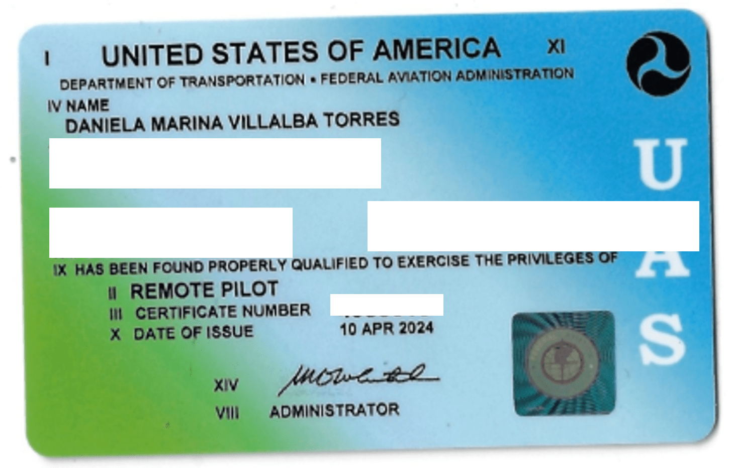
Daniela Villalba's Remote Pilot License
Mike Colston Survey Technician
Certification
Confined Space Entry Certification Confined Space Entry Supervisor Certification
Commercial Driver's License
Experience
Mike is a versatile professional with over a decade of experience operating heavy machinery, including our CAT 309. His expertise extends beyond land clearing to encompass a broad array of skills, such as maintenance and repairs. For the past year, Mike has been a valuable member of the Land and Sea Surveying team, where he has gained extensive knowledge in the field of surveying. His expertise now includes leveling equipment, GPS technology, and utility location.